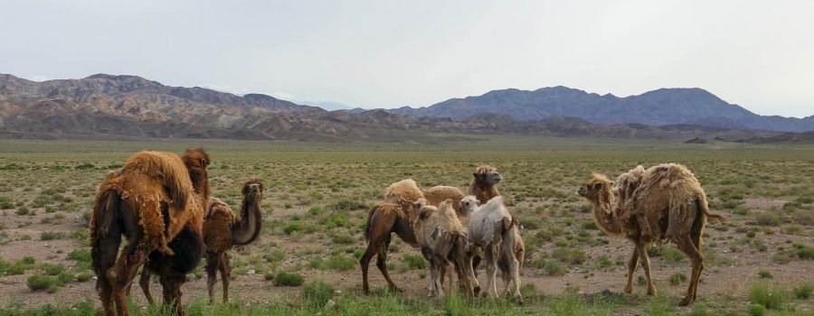
With a length of 182 km and a width of up to 62 km, it will take me 4 days of cycling to get around the lake, excluding any breaks. Today I did part one and arrived at Bokonbayevo, a small town close to the southern coast of the lake. Due to the mediocre visibility today and the fact that the road does not follow directly the lake but passes through the backcountry at some points, I was not too inspired about the natural beauty of the lake. Today’s highlight was something else: I finally saw some camels with actually two humps on their backs (as opposed to the dromedaries seen in Iran and Turkmenistan).
From Kochkor to Issyk Kul
Around 40 km separated me in Kochkor from Lake Issyk Kul, and luckily it all went slightly downhill so I reached the lake at around 9 in the morning after two hours of cycling. I started today early because the weather forecast announced thunderstorms in the area in the afternoon, and I wanted to take advantage of the dry and good weather in the morning.
Shortly after leaving Kochkor, I passed by a typical Kyrgyz cemetery. I don’t really know much about the cultural background, but the small mosque-like tombs all next to each other make an interesting appearance. Unfortunately there were some angry straying dogs living on the cemetery as well, so I refrained from actually entering it.
And a few kilometers later the highlight of the day: I saw a herd of camels which were grazing directly next to the road. I wanted to see camels the whole three months, but all I got to see in Iran and Turkmenistan were dromedaries with only one hump. I was not 100% sure whether the animals belonged to someone, but to me they looked wild and not taken care of. Also, there was no farm or shepherd anywhere nearby.
Following Issyk Kul
I had big expectations about Issyk Kul. There should be high mountains at the northern end which look very beautifully in combination with the deep waters of the salty lake. But first, there was a lot of haze today and the mountains on the northern side of the lake were barely visible, and second, they did not seem so high at all. And on the southern side, where there was no river coming down from the mountains, the landscape was very dry and the road was only marginally interesting because it did not follow the coast line, but went inland with sometimes no view on the lake. All in all I was quite unimpressed about the beauty of Issyk Kul so far. I hope this is mainly because of the bad weather and the fact that the southern road does not follow the coast line. I will be able to say more about it tomorrow evening after completing the whole southern road and arriving in the city of Karakol.
Quality of weather forecast
I have to admit, I am positively surprised about the quality of the weather forecast of international platforms like accuweather.com. Already in the Pamirs, but also in Kyrgyzstan, the weather forecast at least for the next day is very accurate. This was also the case today, the thunderstorms that were announced also formed in the afternoon. Lucky me that I started early and reached Bokonbayevo before heavy rain started. For tomorrow, there are also some thunderstorms announced, but later in the afternoon and less intense. Let’s see if the forecast is right again. I for sure will start early in the morning again.
Detailed Track
Max elevation: 2152 m
Min elevation: 1702 m
Total climbing: 2304 m
Total descent: -2312 m
Total time: 08:43:08


