Starting the day
When we arrived in the dark last night and were looking for a place to put up our tent, the criteria were: outside the city limits of Abarkouh and not too close to the highway. And we thought we found a place that matched both criteria. However, the Iranian like loud music even during the night. We could hear some party music from far away for several hours during the night, reducing the quality of our sleep. And when we got up the next morning, we could actually see where we put our tent: at the border of a garbage dump. Luckily the climate is dry and most of the garbage has been covered by sand and rocks already so it was not smelly.
Going into the desert
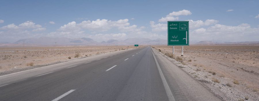
After a camping-breakfast (i.e. Persian bread, tea, some vegetables that were left), we packed our bikes and headed out into the Abarkouh desert. We were hoping to catch some of the tailwind that smoothened our ride yesterday, and for the first 20 km we advanced at a good rate. After that, we got slower and slower, and we did not realize why, because we still had tailwind and the road seemed flat as well. And some point Lucie asked me, if I also have trouble keeping up the speed, or if it is only her. Only after checking my altimeter a few times I realized that we are actually constantly climbing, which was impossible to observe with our bare eyes due to no reference points in the vast and open desert.
Lunch at Deshir
After roughly 60 km we decided to have lunch break in a village at the foot of the XXX Mountains between the desert and Yazd. It was a small and not very touristic village with many mud buildings (some in good shape, some not) and a lovely town square. I used this break to inflate my tires a bit more in hope to advance better afterwards.
Climbing the Zargos Mountains around Shir Kuh Peak (4050m)
After lunch break we continued with our low speed. But at least now we were climbing towards to mountains and we could see the altitude gain. That is much more motivating. We were climbing up to 2650 m, the highest point of today’s tour. As we were driving on the emergency lane of the highway, the inclination was not too steep and after 2 hours of climbing, we reached the pass.
Descent to Eslamiyeh
After climbing, we enjoyed the descent. We did not make it until Yazd as it was still 55 km from the pass. And daylight was getting less and less. So we stopped in Eslamiyeh and went to some local springs. I first thought it is a hot spring with a bath, but it turned out that it was only a water reservoir nicely located at the foot of the mountain. Still, having a place for camping with flowing water is always nice.
As soon as we arrived, we were offered tea by an Iranian family that also spent their day at the springs, followed by snacks etc. It was very welcome after such a tough and long ride. We stayed with the family for a while, set up our tent, washed ourselves in the waters of the springs and then finally went to sleep.
Tomorrow we will then finally reach the desert city of Yazd.


Detailed Track
Max elevation: 2652 m
Min elevation: 1527 m
Total climbing: 1469 m
Total descent: -1106 m
Total time: 09:53:01


